Probing Integration of Blue and Green Spaces in Greater Mumbai: Legal, Planning and Governance Frameworks
By admin
Published On December 27, 2021
There has been a rather high frequency in the formulation of legal enactments and judicial hearings since the past three decades in lieu of the dilapidating conditions of blue and green spaces in Mumbai. The article therefore strives to understand the variances in the intentions and outcomes for blue and green spaces, as part of statutory urban plans and approaches, which are guided by a body of specific legal and institutional mandates. Through detailed spatial examinations, it shares broad planning principles and a set of practical recommendations for guiding the concerned competent authorities.
An Overview of Vulnerable Blue and Green Spaces in the City:
Historical 17th and 18th century excerpts indicate that the purpose of defined, artificial blue spaces such as ‘tanks’ and ‘lakes’ (Tulsi, Vihar and Powai) was fixated on arresting the flow of rains and freshwater storage, facilitated by colonial and domestic philanthropic interests. A review of statutory reports showed that the regional plans of ’67 (4,068 sq.km.) and ’91 (4,238 sq.km.) did not account for major measures related to B/G spaces, noting a loss of 13% area to development in Green Zone II between the plans. Although physical B/G networking and water body preservation are sealed in the strategies of the ’16-’36 draft plan, they are critiqued as restitution measures in lieu of 2,918 sq.km. of land (67% of total MMR) released for development. At the meso level, the SDP 2034 envisions an ‘environmentally sustainable’ global city (458 sq. km.) which apart from proposing the preservation of natural areas, focuses on the requirement of a storm water drainage plan as a means of mitigating climate change, thereby demonstrating an impetus towards infrastructural solutions. Concurrently, there is a dilution of ‘natural’ value given the lack of terminological uniformity as part of the proposed land use plans between DP tenures.
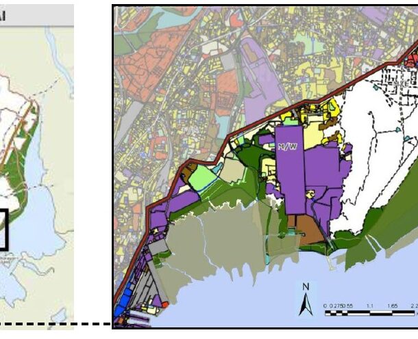
A detailed case study of an area covering the DP extents (SRDP’91 and SDP’34) of Sanjay Gandhi National Park, containing the river sources (Dahisar, Poisar, Oshiwara-Walbhat and Mithi) and lake (Tulsi Vihar and Powai) catchment areas as well as Aarey Colony, revealed losses to development in what was a pre-existing contiguity of natural, virgin land.
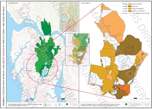
This was on account of varying ownerships, zoning regulation relaxations for an erstwhile ‘No Development Zone’, with further judicial disputes over the present status of forest land and associated transfers. Furthermore, the recent floating of tenders for the rejuvenation of Poisar and Oshiwara rivers, were devoid of nature-based solution considerations.
My Vision for Mumbai’s Green Recovery:
- Form-based DCP Regulations for permissible built uses in SDZ and GZ.
- To preserve the natural courses and provide additional buffer areas for Dahisar, Oshiwara-Walbhat and Poisar rivers by proposing prescriptive Ground Cover and minimal plot size specifications with a goal to retain maximum tracts of virgin land in proximity at the source / upper courses, acts as a vital flood mitigation consideration and river overflow counter measure.
- Invoking Sectoral Masterplan Provision of SDP 2034 for B/G Space conservation at the Ward Level.
- Propose the creation of Local Biodiversity Action and Natural Environment Management Plans for all urban areas either deficient in Open Space provision or near natural areas, especially the ESZ buffer for SGNP, thereby bridging the gap between the ESZ notification and the DP.

- Prohibit Development of Natural Areas as Open Space as part of the SDP 2034.
- With no regulatory frameworks in place for developing open spaces in Greater Mumbai under the BMC Act, developing natural areas is an open invitation to reducing their original effective area and therefore must be prohibited.
- Recognizing the role of the Mayor and Ward Committees for Green Spaces.
- The MRTP Act is solely focused on development and is against decentralization as it clearly specifies the ‘state’ as the sole sanctioning body for the Development and Regional Plans, hence interfering in the grass root affairs of municipalities and citizen interests, working against the 74th CAA and the idea of local self-government. The state must utilize the 74th CAA to enable open space maintenance as an obligatory duty of the BMC.
- 16 Ward committees of Greater Mumbai are legally empowered under the Constitution – representation of people, not bureaucracy in ward committees is essential for safeguarding natural B/G spaces. This ensures inclusivity, transparency and can help better guide state and parastatal authorities in matters related to or otherwise directly affecting natural B/G spaces due to urban development.
- With the state-level River Regulation Zone Policy revoked, there is an opportunity to formulate new state policies for ensuring floodplain and waterbody protection. The alteration of natural river courses (ex: Mithi river mouth altered by MMRDA) must be prohibited and exercised only on an emergency basis post ESIA and public consultation. Integration was probed to rely more on spatial mergers in the case of Greater Mumbai.
For Mumbai Matters:
Name: Berjis Driver
Organization: Centre for Environmental Planning and Technology (CEPT), Ahmedabad
Berjis Driver is an Architect and Urban Planner. His passion for wetlands, reforming the water regimes and natural environment conditions in Indian cities has been reflected through the body of his academic efforts and brief professional experiences.